Friday, August 10, 2012

gvSIG CE at AGIT 2012


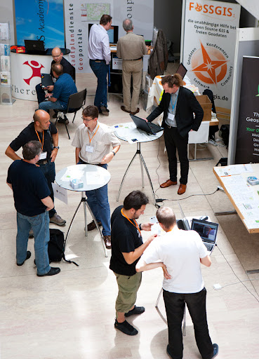
gvSIG CE joined the FOSSGIS booth at AGIT 2012 where many interested visitors dipped into the latest trends in free and open source GIS software (FOSSGIS). Coming from all backgrounds people highly appreciated the friendly co-presenting of FOSSGIS e.V., Open Street Map, QGIS, Mapfish and gvSIG CE.
The Open Source Day at the Expo Forum on Friday yielded lively and fruitful discussions among FOSSGIS experts from all projects and users of all stripes.
Still, future efforts have to be made in disseminating the benefits of FOSSGIS in general besides promoting individual projects.
See you at AGIT 2013!


Wednesday, May 30, 2012

New Committer

Dear all,
we would like to announce a new committer in gvSIG CE: Fernando González. Fernando (Geomati.co) is a developer with a lot of experience in open source. Geomati.co has contributed with several open source projects as gvSIG Desktop, gvSIG CE, gvSIG mini, thredds, geoserver, geoexplorer, GGL2 and Geotools.
He sent patches to our team and developed new functionalities with us. This is a new example to be included in gvSIG CE, made together with Ruth:
- Automatic loading of legends:
Fernando, thank you very much for the great work you are making and welcome to the project.
Best regards!
Jose Canalejo

gvSIG CE Team
www.gvsigce.org

Wednesday, May 2, 2012

gvSIG CE at 2012 Washington GIS Conference

Karsten Vennemann, principal of Terra GIS Ltd. and education contact for the “Cascadia Users of Geospatial Open Source” group, is ready to present a 4 hour workshop at the WAURISA 2012 conference: “Introduction to gvSIG CE and geo-processing with SEXTANTE”. 

The workshop consists of the following three parts (with 15 minutes breaks in between sessions):
1. Introduction to gvSIG CE Desktop GIS
60 minutes, presentation style
Objective: Participants will get a short introduction to free and open source GIS tools,  the desktop GIS gvSIG CE (Community Edition)  and the SEXTANTE library. The overview will include topics such as general GIS functionality in gvSIG CE, supported data formats, editing of GIS data, layout and cartography, accessing spatial databases and available extensions for gvSIG (e.g. 3D, Raster and Remote Sensing, and Network Data Analysis) . A discussion of geo-processing and spatial analysis with native gvSIG and with SEXTANTE tools will close the general overview.
2. “Hands-on” exercises and examples using gvSIG CE
75 minutes, demonstration style, participants can follow the demos “hands-on” on their own (windows based) laptop with gvSIG CE installed.
The exercises will cover the general use of gvSIG: editing of GIS data,  accessing spatial databases, and layout & cartography
Objective: The examples will illustrate how to use gvSIG CE as a general desktop GIS
3. “Hands-on” exercises and examples for Spatial Analysis and Geo-processing with gvSIG CE and SEXTANTE
75 minutes, demonstration style, participants can follow the demos “hands-on” on their own (windows based) laptop with gvSIG CE installed.
The exercises will cover the use of spatial analysis and geo-processing tools in gvSIG CE for raster and vector data: native gvSIG tools, and tools available via the integrated SEXTANTE library (also includes SAGA GIS, GRASS and R (Statistical package) algorithms).
Objective: The examples will illustrate how to use  gvSIG CE and SEXTANTE for Spatial Analysis and Geo-processing in order to learn about the capabilities and functionality available.

Workshop presenters/instructors
Karsten Vennemann, Terra GIS (GIS Analyst and instructor for OS GIS)
GIS Consultant, frequent speaker and OS GIS Instructor
http://terragis.net

Links
gvSIG CE (Community Edition): http://gvsigce.org
SEXTANTE: library http://www.sextantegis.com
Terra GIS: http://terragis.net

Thursday, December 29, 2011

SEXTANTE article in GEO Informatics

SEXTANTE a free Java Library for Geospatial Analysis:
Authors: Ruth Schönbuchner, José Canalejo, Victor Olaya, Juan Carlos Gimenez
Geo Informatics, 8 December 2011 Volume 14 - ISSN 13870858


SEXTANTE  is a free library for Geospatial Analysis that includes a large set of geoprocessing tools. It contains more than three hundred algorithms for both raster and vector data processing. For most of them, contextual help has been prepared, which provides insight into the functionality of the tool.
In the current version of SEXTANTE it is possible to use an interface to the free software GRASS GIS and SAGA. Since august 2011 SEXTANTE can be also integrated into ArcGIS.
SEXTANTE can be improved by programmers to incorporate analysis functionalities into their software.
Although many innovations have been realized, the SEXTANTE project team members continue with new interesting ideas such as the integration of R, the powerful statistical software, into SEXTANTE.
Enjoy reading this article!

Sunday, October 30, 2011

gvSIG Community Edition TECHNOLOGY PREVIEW available for testing

An early preview of the upcoming gvSIG Community Edition 1.0 is available for download here.
It is not intended for use in a production environment. We expect that there are still missing features in this release. In particular, the following features are NOT YET included:
  • updated 32/64 bit binaries (raster drivers)
  • GRASS and SAGA GIS binaries (via SEXTANTE)
  • third-party extensions (e.g. OpenCAD, NavTable)
  • the new extensions manager tool
We have included a SEXTANTE snapshot from 08/28/2011. Functionalities of GRASS GIS and SAGA can be added to the SEXTANTE Toolbox following the instructions of this document. You will see all the available raster- and vector tools from SEXTANTE, SAGA, GRASS GIS and gvSIG CE which all together are currently 760 algorithms.
A continuously updated release announcement, detailing the progress on new features and bug fixes can be found here.
This is a zero-install distribution. Simply unpack it somewhere on your harddisk and start it:
  • Linux: start bin/gvSIG.sh
  • Windows: start bin/gvSIG.bat
  • Mac OS X: double-click the App folder
Please report your findings to our users mailing list.
The gvSIG Community Edition project team.